|
 DOC DOC
Intranet
 photos photos

|
 WORKSITES MAP Egypt France Italy Lebanon Morocco Spain WORKSITES MAP Egypt France Italy Lebanon Morocco Spain
 Egypt Egypt
General view
Egypt's main water sources are the River Nile and a very limited amount of fossil ground water in the Eastern and Western Deserts and in the Sinai Peninsula. About 84% of available water resources are used for agricultural production. Egypt is allocated a fixed quota of all Nile water resources equivalent to 55.5 Milliard m3 annually. Demands on this fixed amount of water resources drastically increases due to the high growth rate of population at an average of 2% annually. This goes along with the growing needs to irrigate more areas reclaimed in desert lands to satisfy food and agricultural production needed. Development of industrial sector and tourism need further water resources. However, due to the low efficiency of traditional irrigation practices and seepage losses, a large amount of water supplied for irrigation either leaks to the drainage system or recharges the aquifers of the Nile Delta and Valley or is lost through evaporation.
Given the long history of irrigated agriculture in Egypt, a number of traditional forms of farmer participation provide a good background for formal participation of the private sector in water management. Major informal forms of participation include the munawba and motarafa system and sakia ring for collective pumping of water. The participation of stakeholders in water management has been developed over the past decade to allow more cooperation and coordination amongst the different stakeholders and relevant government institutions.
Problems with the non-improved irrigation system in the old lands were largely related to the inequitable supplies of water between the head and the tail of a mesqa, in addition to lack of proper maintenance. The need for improvements was not solely due to problems of the old traditional system. It emanated from the desire to improve the efficiency of water use so as to avert potential water scarcities at the national level. New and expanded demands for water use compete with the traditional use of water for irrigation in the old lands and thereby call for an improved system that does not over-use the increasingly scarce resource.
The creation of water users' associations (WUA) in Egypt was initiated as part of an Irrigation Improvement Project (IIP) that begin in 1977 - then named as the Egypt Water Use and Management Project (EWUMP). The creation of WUAs in Egypt was recommended in 1984 in a final report by the EWUMP and made operational at the improved mesqa level in 1988 as an essential component of the IIP package. In 1992, an Irrigation Advisory Service (IAS) was initiated within the Ministry of Irrigation and Water Resources (MIWR) to work with WUAs. These associations did not have a legal entity until 1994, when irrigation and drainage law 12 was amended by law 213 to allow for establishing WUAs in the new lands and in the improved irrigation project area in the old land at the mesqa level. There are more than 3000 WUAs all over the country but with intensive appearance in seven governorates in the Delta and Valley of the Nile. A recent national sample survey was undertaken the last two years has showed great need to rehabilitate existing associations and consider a long term and comprehensive building up capacity programme for the existing and forthcoming WUAs.
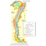
Egypt worksites situation
The Case studies
Case study N°1 : Fayoum Area
Click on image
 Fayoum governorate is a depression area that has established a very special irrigation system dependent on the 'Hadarat' to regulate the flow of water. Operation of this system necessitates the establishment of an organization called 'Motarfa'. Some of these areas have been developed physically and from the social organization point of view. A recent assessment of these new changes refers to the need of further follow up and more attention to the replacement process as well as the capacity building and the relationship among the official irrigation department, the water users associations and other water users. Fayoum governorate is a depression area that has established a very special irrigation system dependent on the 'Hadarat' to regulate the flow of water. Operation of this system necessitates the establishment of an organization called 'Motarfa'. Some of these areas have been developed physically and from the social organization point of view. A recent assessment of these new changes refers to the need of further follow up and more attention to the replacement process as well as the capacity building and the relationship among the official irrigation department, the water users associations and other water users.
Research implemented by the members of CRDRS, through a recent national survey for the assessment of WUAs have enabled them to pin point the main socio-economic and technical constraints that affect, negatively, the efficiency of the new social organisations in the Fayoum area. It would be much easier for the CRDRS team and other partners to get benefit from the recent experience of that team and all their previous work in this connection.
Case study N°2 : Minya (Nile valley)
Click on image
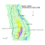 Irrigation is using flood (surface). Tertiary canals (Mesqa) are relatively shorter in length and serve smaller areas and less number of farms. Lack of hierarchy of the WUAs does not help efficient use of resources available for these organisations. Establishment of federations at higher administrative levels is a step forward. Irrigation is using flood (surface). Tertiary canals (Mesqa) are relatively shorter in length and serve smaller areas and less number of farms. Lack of hierarchy of the WUAs does not help efficient use of resources available for these organisations. Establishment of federations at higher administrative levels is a step forward.
|
Click on image
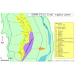 This map is a zoom over the zone study that shows the structure of the irrigation system in the so call MANTOUT COMMAND AREA.
Mantout is the name of the main canal in blue gray.
This map is a zoom over the zone study that shows the structure of the irrigation system in the so call MANTOUT COMMAND AREA.
Mantout is the name of the main canal in blue gray.
|
Case study N°3 : Behera area including Nubaria or South Tahrir Desert Reclaimed Lands (Nile delta)
Click on image
 |
Most areas in the old land use flood (surface) irrigation method while in the newly reclaimed desert lands farmers are obliged -by law- to apply modern irrigation techniques such as sprinkler and dripping. More problems related to the lower quality of water used and recycling of drainage water to compensate the shortage of water resources are encountered by the farmers in the area. Tertiary canals (Mesqa) in old lands are relatively longer in length and serve larger areas and greater number of farms. This needs more efficient and effective managerial approaches and organization of the WUAs through some information and building capacity programs. Lack of hierarchy of the WUAs does not help efficient use of resources available for these organizations. Establishment of federations at higher administrative levels is a step ahead.
|
|
Related ressources
|
Agricultural
|  | Economic issues regarding tertiary canal improvement programs, with an example from Egypt (article) |  | Study of an irrigated perimeter in the process of rehabilitation in the province of Beheira, Nile Delta, Egypt (report) |  | Diagram : landscape model in the region of Damanhour - Egypt (figure) | | Diagram: Collective Pumping Unit and distribution to fields - El Resqa, Behera, Egypt (figure) |
Cartography - GIS - Remote sensing
|  | Fayoum & Al Minya basins (map) | | IRD Sphaera map library : Dispersion of the Nile delta rural localities in 1976 (map) | | IRD Sphaera map library: maps produced by the IRD for Egypt (map) | | IRD Sphaera map library : The working population employed in the primary sector in the Nile delta in 1986 (map) | | IRD Sphaera map library : Illiterate population in the delta of the Nile in 1976 (map) | | Seila area ISIIMM study zone, Fayoum, Egypt (map) | | Egypt Minya 1972 (map) | | Mantout command area - Minya, Egypt (map) | | IRD Sphaera map library : Annual rate of population increase in the Nile Delta 1960-1976 (map) | | IRD Sphaera map library : Annual rate of population increase in the Nile Delta 1976-1986 (map) | | World:Map of Tahnasha - Muhafazat al Minya, Egypt (map) | | Nile river basin (map) | | Intake of El Resqa Canal and irrigation system - Behera, Egypt (map) | | IRD Sphaera map library : Nile Delta Population Densities in 1986 (map) | | Egypt - Minya : Situation map of ISIIMM Study Zone (map) | | Egypt Minya - Study zone Irrigation system (map) | | Seila - ISIIMM study zone perimeter in Fayoum, Egypt (map) |  | Egypts ISIIMM worksites situation map : Behera (El Resqa, Newlands), Fayoum (Seila), Menia (satellite_image) | | Egypt worksites ISIIMM - Behera, Fayoum, Menia (satellite_image) | | Chaine of bassins in the Nile valley in the XIXth century (figure) |
Case studies
| | ISIIMM project: Case studies synthesis - Egypt (report) |
Economy
| | Politically Optimal Tariffs: An Application to Egypt (report) |
Historical
| | Two centuries of hydraulic and coton activities in the Nile valley (article) |  | Agricultural Associations for land irrigation according to the Italian type of Consorzii (bulletin) | | Bibliographic report on the use of water for agriculture in Egypt from antiquity to modern times (report) |  | The agriculture of Egypt (Chapter 11) : the history of agricultural development (doc) | | Hydraulic and agricultural history and struggle against salinisation in the Nile Delta (doc) | | Right and water institutions in ancient Egypt (doc) | | Summary of landed property history in Egypt (figure) |
Hydrological - Hydraulic
|  | Study of a hydraulic system in the course of transformation: the canal El Resqa, Nile delta (diaporama) | | Egypt - Second pumping rehabilitation project and the national drainage project (report) | | Nile river & Egypt annual water balance for 1997 (figure) |
Images / Photos
| | Photos ISIIMM coordination unit mission in Fayoum, Egypt, December 2003 (photo) | | Photos ISIIMM coordination unit mission in Minya, Egypt, December 2003 (photo) | | Photos of Behera by Thierry Ruf - IRD, Egypt, April 2004 (photo) | | Photos of Behera by Sylvain Lanau - CNEARC, Egypt, April 2004 (photo) | | Photos of El Resqa, region of Behera by Nicolas Ferraton, Egypt, April 2004 (photo) |
ISIIMM Newsletter
| | ISIIMM newsletter N°7 - December 2005 (bulletin) | | ISIIMM newsletter N°10 Special Issue - Juin 2006 (bulletin) |
ISIIMM Posters
|  | Seminar poster - Comparison of irrigation management in mediterranean plains and deltas environments : the Egyptian experience (poster) |
ISIIMM project
|  | SWaMMA Solid Waste Management in Mostafa Agha, Egypt (link) |
Methodology - guidelines
| | Coexistence of different irrigation systems in the Nile Delta region (article) |
Seminars
| | International Seminar Program : Water poverty and social crisis - Perspectives for research and action, Agadir-Morocco, 11-15 December 2005 (doc) |
Social
| | Mechanisms of impoverishment of the rural poor in contemporary Egypt (article) |  | Hydraulic crisis and peasant poverty in Egypt - conference Habib Ayeb (video) |
Territorial
| | Worksites presentation Egypt - seminar ISIIMM June 2003 (article) | | Map of the Nile Delta and Behera (ISIIMM case study) (map) | | Averting a Water Crisis in the Middle East: Make Water a Medium of Cooperation Rather Than Conflict (report) |
Transversal
| | Egypt from an Indian perspective and vice-versa (March-April 2004) (report) |
Water management
|  | Water Demand Management: Approach, Experience and Application to Egypt (biblio) | | Chart: The Nile basin, regime, development and cultivated territory in Egypt (map) |
Water management in plain societies
| | Study of the operation of a hydraulic system in transformation: the irrigation canal El Resqa, Behera governorate, Nile delta (report) |
|
|
)
)
)
)

)